Satellites have long been our eyes in the sky, providing critical images and data about Earth’s forests cities coastal waters, and more. These data streams empower scientists governments and environmentalists to understand and protect our planet. But integrating the flood of information from various satellites into a unified, real time picture remains a challenge.
Now, Google DeepMind has introduced a groundbreaking AI model, AlphaEarth Foundations, which acts as a virtual satellite AI offering detailed, nearly real time maps of the Earth at any place and time.
What is Alpha Earth Foundations? The Rise of Virtual Satellite AI
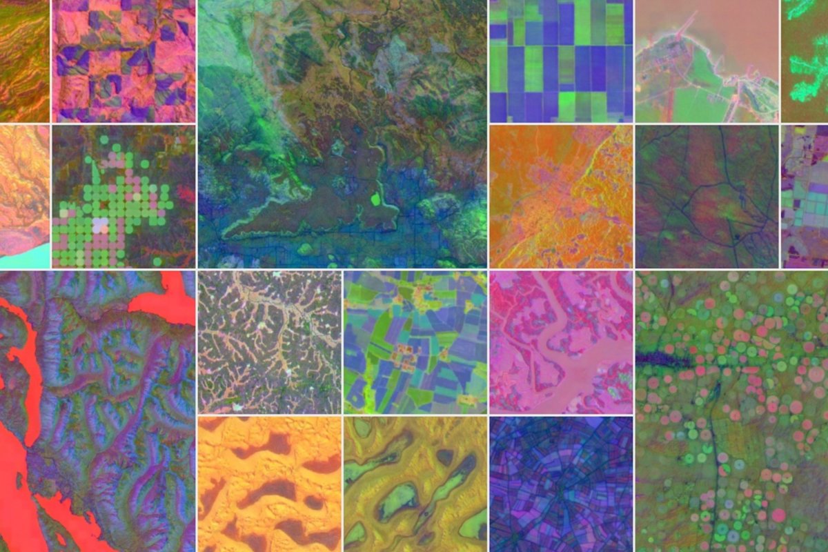
Google’s AI division DeepMind recently unveiled AlphaEarth Foundations, a revolutionary AI model designed to mimic the function of satellites but with enhanced capabilities. Unlike traditional satellites that physically orbit Earth capturing images intermittently, this AI processes a vast array of satellite data, satellite imagery, and other geospatial information to generate high resolution maps instantly.
Christopher Brown, a research engineer at Google DeepMind describes AlphaEarth Foundations as a virtual satellite capable of mapping the world at any place and time. This means researchers no longer have to wait for satellite overpasses or deal with inconsistent data from different sources. Instead, they get a cohesive, high detail view of Earth whenever they need it.
How Does This Virtual Satellite AI Work?
AlphaEarth Foundations employs advanced machine learning and computer vision techniques to integrate data from multiple satellite sources. The AI ingests historical satellite images, weather data, land-use records, and environmental indicators to build an up to date, dynamic picture of the planet.
By training on millions of satellite images, the AI learns patterns in land changes, urban growth, deforestation, and coastal shifts. It can then predict and fill gaps where satellite data might be missing or outdated, effectively functioning like a satellite in virtual form but without the physical limitations. In simple terms, the AI acts as a centralized hub that continuously analyzes, predicts, and updates Earth’s landscape in near real time.
1. Real Time, Comprehensive Mapping
Traditional satellite data can have time lags, varying resolutions, and inconsistent formats. AlphaEarth Foundations overcomes these challenges by unifying disparate data streams into a seamless, up to date map accessible on demand.
2. Environmental Monitoring and Disaster Response
Experts see enormous potential for this virtual satellite AI in tracking deforestation, monitoring wildfires, and predicting floods. Because it can update continuously, governments and NGOs can respond faster to environmental crises.
3. Urban Planning and Infrastructure
Cities are dynamic entities, growing and changing rapidly. Urban planners can use Alpha Earth Foundations to monitor expansion, assess infrastructure needs, and plan sustainable development with more accurate data.
Tracking Deforestation in the Amazon
One practical application of AlphaEarth Foundations is its use in monitoring the Amazon rainforest, one of the world’s most critical ecological zones. Deforestation has been a persistent problem, with satellite imagery often delayed or clouded by weather conditions, limiting timely intervention.
With virtual satellite AI, researchers have been able to observe illegal logging activities in near real time. This instant visibility allows local authorities to deploy resources quickly to protect vulnerable areas. Maria Gonzalez, an environmental scientist who works with South American forest preservation agencies, shared her experience.
Before AlphaEarth Foundations, our team relied heavily on sporadic satellite images. Often, by the time we detected deforestation, the damage was done. Now, with this virtual satellite AI, we receive updated maps daily, sometimes hourly, which has transformed our conservation efforts.
What Industry Leaders Say
Dr. Neil Roberts, a geospatial AI expert at Stanford University, commented on the breakthrough. AlphaEarth Foundations represents a paradigm shift in how we use AI to understand our planet. By integrating vast data sets and providing near real time updates, this virtual satellite AI enhances our ability to tackle environmental challenges and urban development in unprecedented ways.
Similarly, Susan Lee, director of Urban Sustainability at the World Resources Institute, highlighted its importance for cities. With climate change accelerating, cities must adapt quickly. Tools like AlphaEarth Foundations offer planners the data needed to build resilient urban environments that can respond effectively to natural disasters and population growth.”
How I Witnessed Virtual Satellite AI in Action
As a freelance journalist covering technology and environmental issues, I had the chance to test AlphaEarth Foundations in collaboration with a team tracking coastal erosion in Florida.
Previously, this team depended on periodic drone flights and satellite images to assess how rising sea levels affected shorelines. With the virtual satellite AI, they gained continuous, detailed insights into erosion patterns.
Watching the AI generate updated maps that highlighted vulnerable areas helped the team prioritize interventions. It was eye opening to see how virtual satellite AI could democratize access to critical environmental data, even for small local agencies with limited budgets.
Challenges and Future Potential
While AlphaEarth Foundations marks a significant technological advance, challenges remain. Handling vast amounts of satellite and geospatial data raises privacy concerns, especially for sensitive regions.
The AI’s predictions rely heavily on training data. If the data is biased or incomplete, the AI’s maps may reflect inaccuracies. Processing global data in real time requires tremendous computational power and infrastructure investment.
Despite these hurdles, the potential for virtual satellite AI is enormous. Beyond Earth observation, future versions could integrate IoT sensor data, drones, and even social data to create a holistic digital twin of the planet.
The Future of Earth Mapping is Virtual
Google’s Alpha Earth Foundations virtual satellite AI is a landmark innovation that is transforming how we view and interact with our planet. By providing detailed, timely, and integrated maps, it empowers scientists, policymakers, and communities worldwide to make smarter decisions for sustainability and resilience.
As this technology evolves, the line between physical satellites and AI powered virtual satellites will blur, ushering in a new era of planetary awareness and stewardship.